Tour America's Treasures


An invitation to tour America's historical sites...

Wednesday, April 18, 2012

Denver Museum of Nature and Science


View Denver Museum of Nature and Science in a larger map

Visit our Tour Destination: Colorado page to see the entire tour of the state’s Save America’s Treasures sites.


Exterior of the Denver Museum of Nature and Science.
Photo by Chris Schneider/Chris Schneider Photography.
© Denver Museum of Nature and Science

Denver Museum of Nature and Science
2001 Colorado Boulevard
Denver, CO


The Treasure:  The anthropology collections at the Denver Museum of Nature and Science comprise over 5,000 archaeological and ethnological artifacts that illuminate the Native American cultures of North America with a special emphasis on the Rocky Mountain region.

Accessibility:  The Denver Museum of Nature and Science is open daily from 9 to 5. Selected items from the anthropology collections are always on view at the North American Indian Hall. Many past special exhibitions have drawn from the collections. Over 300 digitized images from the anthropology collections can be viewed online at the Denver Museum’s Image Archives.

A Peace medal with the image
of Thomas Jefferson. Peace
Medals were passed to Native
American leaders as tokens
of  friendship and concord.
© Denver Museum of Nature
and Science 
Background:  While the museum was officially founded in 1900, its roots extend even further back into Colorado’s history. Twenty-five years earlier, Edwin Carter (1830-1900) established a log cabin museum in Breckenridge, Colorado, where he showcased his collection of over 3,000 natural history specimens. At Carter’s death in 1900, this collection was purchased to form the core of Denver’s new museum.

In 1937, under the leadership of its new director Dr. Alfred Marshall Bailey, the Denver Museum established a Department of Archaeology with a focus on Paleoindian and Archaic archaeology. The museum further expanded to include a Department of Anthropology upon the donation of the 12,000-item Crane Collection of North American Indians in 1968.

Today, the Denver Museum’s Department of Anthropology strives to be the best understood and most ethically held anthropology collection in North America. They endeavor to achieve this goal through scientific research, educational outreach, and programs that support in-depth research by Native American students and scholars.

The White Horse Winter Count is a historical narrative in pictorial form
from the Cheyenne River Reservation. It begins in 1789 with a dark bird
at its center and then spirals clockwise until 1912, telling the stories of
people and important events such as the Leonid meteor shower in 1833
and Haley's Comet in 1910.
© Denver Museum of Nature and Science

Rare split-twig figurine found in a cave in southwestern Colorado.
© Denver Museum of Nature and Science

Captain William Clark used this English-made telescope during his famous
1804-1806 expedition with Meriwether Lewis.
© Denver Museum of Nature and Science

Notes from the Editor:  While the Save America’s Treasures grant broadly supported conservation, improved storage, and archival processing of the wide range of artifacts in the collection, it also enabled the Denver Museum to process, preserve, catalog, and digitize the remarkable Ruth Underhill Collection.

At the age of 47, Ruth Underhill (1883-1984) decided to become an anthropologist, studying in the graduate anthropology program at Columbia University under Professor Franz Boas (whose archive was conserved as a Save America’s Treasures project at the American Philosophical Society in Philadelphia). Boas suggested that Underhill conduct a field study of the culture of the Tohono O’odham Nation, whose people live in the Sonoran Desert of southeastern Arizona and northwest Mexico. The Tohono O’odham welcomed Dr. Underhill into their community and trusted her to respectfully learn their ways.

A Tohono O'odham basket presents a rare and observant
design of a steam locomotive.
© Denver Museum of Nature and Science
Although middle-aged at the outset of her new career, Dr. Underhill lived to enjoy a long and very active professional life primarily focused on the cultures of the Native Americans of the Southwestern United States. Her field journals, and many of her personal papers, films, sound recordings, and photographs, were donated to the Denver Museum at her death in 1984. Included within this invaluable record of her scholarly investigations and field work are the earliest known transcriptions of the Tohono O’odham language.

Of her time with the Tohono O’odham, Dr. Underhill recalled, “They thought I was a witch because I could write those things down [using a phonetic alphabet] and read them back to them. Often, those songs, as the old people sang them, contained archaic words no longer used… then I would have to have one of them tell me what the old words meant, and finally I would translate the whole thing to English.”

Other Recommended Sites:  In Denver, an old organization is opening a brand new museum this year. Dating all the way back to 1879, the Colorado Historical Society is reinventing itself for the 21st century with a new name (Colorado History) and a new museum, the History Colorado Center, scheduled to open on April 28, 2012 in downtown Denver. The History Colorado Center will celebrate the organization’s sizeable historic collections and offer high-tech exhibits and hands-on education programs. Along with the public museum space, the new building will be home to a research library, the State Historical Fund offices, and the Office of Archaeology and Historic Preservation.

Renowned Hopi woodcarver Michael Calnimptewa
made this Koyaala, a northeastern Pueblo-type
clown that is often present during the Hopi
kachina dances.
© Denver Museum of Nature and Science


This T. rex greets visitors at the Denver Museum of
Nature and Science.  Photo by Chris Schneider/
Chris Schneider Photography.
© Denver Museum of Nature and Science


Tour America's History Itinerary
Friday’s destination:  Hutchinson Homestead Ranch
Monday’s destination:  Crow Canyon Archaeological Center

© 2012 Lee Price

Monday, April 16, 2012

Destination: Colorado


View Colorado in a larger map


Tour America's Treasures editor
Lee Price at Florissant Fossil Beds.
Welcome to Colorado! That’s me in the neighboring photo, always ready to celebrate any place that has a National Monument site dedicated to the preservation of immaculately detailed plant and insect fossils. While not one of our official Save America’s Treasures sites, Florissant Fossil Beds National Monument is definitely still a Colorado treasure.

We enjoyed a family vacation in Colorado last year, arriving at Denver International Airport and immediately taking in the first of many memorable landscapes—the clear demarcation between eastern Colorado’s Great Plains and the Rocky Mountains to the immediate west of Denver. Two radically different worlds meet here, roughly pasted together on a grand scale.

History below the ground, as well as
above, in Colorado.
Colorado is loaded with ranching history, mining history, Native American history, and layers upon layers of prehistory. The land is wide and wild and beautiful. And when you need a break from historical exploration, there are plenty of opportunities for other recreational activities, particularly at Colorado’s internationally famous ski resorts.

Denver provides the central urban hub for the state. The Great Plains and preserved short-grass prairie lands (where the antelope still roam) are to the east of Denver. Directly to the south of Denver is a varied landscape of mountains, deserts, forests, plains, and even white-water rivers. The Rocky Mountains—including the legendary Rocky Mountain National Park—are to the west. And, finally, don’t forget the scenic canyons and hot springs of the famous Four Corners area in the Southwest region of the state.

For more professional orientation and plenty of solid Colorado tourism advice, visit the Official Site of Colorado Tourism, Denver Colorado Tourist & Vacation Information, and Colorado Vacation Planning.

Our Tour America’s History exploration of Colorado’s 15 Save America’s Treasures sites begins on Wednesday.


The Rocky Mountains as seen from our resort in Breckenridge.

Tour America's History Itinerary
Wednesday’s destination:  Denver Museum of Nature and Science
Friday’s destination:  Hutchinson Homestead Ranch

© 2012 Lee Price

Monday, April 9, 2012

Clover Bend National Historic Site


View Clover Bend National Historic Site in a larger map

Visit our Tour Destination: Arkansas page to see the entire tour of the state’s Save America’s Treasures sites.

Aerial shot of the Clover Bend National Historic Site campus.
Photo courtesy Clover Bend Historical Preservation Association.

Clover Bend National Historic Site
State Highway 228
Lawrence County, AR


The Treasure:  The restored buildings at Clover Bend National Historic Site recall the idealism of the New Deal’s Farm Security Administration programs.

Background:  As the Depression worsened in the early 1930s, small-scale farmers—including sharecroppers, tenant farmers, and poor landowning farmers—were particularly hard hit. As banks foreclosed on properties, displaced farming families hit the road, facing very uncertain prospects. Established in 1935, the Farm Security Administration (FSA) was an effort of the New Deal to assist struggling farmers.

Logo of the
Farm Security Administration (FSA).
At various locations in the country, the FSA purchased farmland, divided the land into smaller farmsteads, then recruited tenant farmers to work the land with some government support. In many cases, the families signed leases and purchase contracts that would lead toward land ownership.

Through an FSA program, the federal government purchased approximately 5,000 acres of foreclosed plantation property at Clover Bend. The land on the east side of the Black River had been transformed into good crop-bearing plantation farmland in the mid-19th century. However, even before the Depression, much of the land had sunk bank into swamp water and overgrown thickets.

The FSA’s Clover Bend Resettlement Program was particularly successful because it leased its 86 farmsteads to local families who already understood how to farm the sandy yet moderately fertile soil. Most participating families received a house, a barn, an orchard, a poultry house, and assorted outbuildings. The price for the property averaged $8,000 with the families paying $200 per year toward the long-term purchase.

The Clover Bend farmers participated in a medical co-operative plan that assured doctor’s care and hospitalization. The central grist mill, a mowing machine, and other farm equipment were cooperatively owned and shared. The original community center building was converted into Clover Bend School in July 1939, with an initial enrollment of over 200 students. It remained the local school until its closure in 1983.

South side of the Clover Bend gym prior to restoration.

South side of the Clover Bend gym, following restoration.

Notes from the Editor:  John Steinbeck’s classic novel The Grapes of Wrath is dedicated to “Carol who willed it” and “Tom who lived it.” Carol was Steinbeck’s wife. Tom was Tom Collins, the first administrator of Weedpatch Camp, the most famous of the FSA camps, located south of Bakersfield, California. Collins worked as an advisor to Steinbeck during his writing of the book and as a technical advisor to John Ford when the book was filmed in 1940, as well as serving as the model for the character Jim Rawley in the book.

Henry Fonda as Tom Joad in
The Grapes of Wrath (1940).
In the movie of The Grapes of Wrath, our hero Tom Joad (Henry Fonda) meets with the Caretaker (the Collins-based character who manages the Farmworkers’ Wheat Patch Government Camp). Tom expresses amazement at the camp’s humane policies:

Tom:  You aimin’ to tell me the fellas that are runnin’ the camp are just fellas that are campin’ here?
Caretaker:  That’s the way it is.
...
Tom:  You got dances, too?
Caretaker:  They have the best dances in the county, every Saturday night.
Tom:  Who runs this place?
Caretaker:  Government.
Tom:  Why ain’t there more like it?
Caretaker:  You find out. I can’t.

In many ways, the lesser-known Clover Bend was a greater success than Weedpatch. Most of the families in the program quickly received deeds to their properties and they improved and beautified the local community. The school served as a proud center for the community for many years and remains fondly remembered by its graduates.

Congress greatly reduced the work of FSA as the United States entered World War II. Conservatives had always strongly objected to the level of government involvement in the FSA programs, most extremely comparing it to the collective agricultural policies of the Soviet Union. In 1946, the FSA was formally replaced by the new Farmers Home Administration, which had a much more limited focus of extending credit for agriculture and rural development.

Other Recommended Sites:  The Arkansas State University Museum in nearby Jonesboro explores the history of Northeast Arkansas and the Mississippi River Delta region. Among the exhibits is a reconstruction of “Old Town Arkansas,” a tour of 13 shops and offices representative of the type of places you might have found in this area back in the period of 1880 to 1920.


Restored farmstead at Clover Bend National Historic Site.
Photo courtesy Clover Bend Historical Preservation Association.

Tour America's History Itinerary
Monday’s destination:  Next stop: Colorado!

© 2012 Lee Price

Friday, April 6, 2012

Camp Ouachita


View Camp Ouachita in a larger map

Visit our Tour Destination: Arkansas page to see the entire tour of the state’s Save America’s Treasures sites.


The Great Hall, also known as Ogden Hall, at Camp Ouachita.
Photo courtesy Ouachita National Forest.

Camp Ouachita
Off Route 324, northern side of Lake Sylvia
Ouachita National Forest in Perry County, AR


The Treasure:  Camp Ouachita is the only surviving Girl Scout camp built by the Works Progress Administration and the first Girl Scout camp constructed in Arkansas.

Background:  President Franklin Delano Roosevelt launched the Works Progress Administration (WPA) in 1935 to ease the unemployment crisis by funding a broad range of public works projects. From its beginning in 1935 until the official close of the program in 1943, the WPA provided almost 8 million jobs and spent approximately $13.4 billion. WPA projects included the construction of roads, bridges, and buildings, as well as arts, drama, media, and literacy projects.

One of the WPA projects was the construction of Arkansas’ first Girl Scout camp. Sue (Worthen) Ogden, the president of the Little Rock Girl Scout Council, spearheaded the effort to create the camp, using WPA grants, private donations, and U.S. Forest Service support. The camp was located deep in the forest on the northern shore of Lake Sylvia.

The centerpiece of the Girl Scout camp was the Great Hall, also known as Ogden Hall after Sue Ogden. Other buildings included the caretaker’s residence, the director’s cabin, the camp’s infirmary, staff cabins, sleeping cabins, a bathhouse, and tent platforms. Camp Ouachita served as a popular Girl Scout camp from its dedication in 1937 until its formal closing in 1979.

In the 1990s, efforts began to restore and reopen the camp as part of the full range of recreational activities around Lake Sylvia. Save America’s Treasures funding was instrumental in restoring the historic Great Hall.

Ouachita National Forest.
Source: Wikimedia Commons
Notes from the Editor:  Encompassing nearly 2 million acres, Ouachita National Forest spreads across 13 counties in Arkansas and two counties in Oklahoma. The Ouachita River runs through it, giving the forest its name. The river's name dates back to pre-European times, with the word “Ouachita” or “Washita” describing a sparkling silver river running through good hunting grounds. The Caddo people lived in this area long before the arrival of the Europeans. Although largely relocated to the west, the Caddo Nation remains active today, with its tribal council and a Caddo Heritage Museum located in Binger, Oklahoma.

There are still old growth forests in Ouachita National Forest, along with lakes, rivers, valleys, and mountains. Naturally, hiking, mountain biking, horseback riding, canoeing, fishing, and camping are popular activities. The Ouachita National Forest site has full information available for visitors interested in exploring the area, including detailed information on the many trails that run through the park.

Other Recommended Sites:  Hot Springs National Park is located just an hour’s drive southwest of Camp Ouachita. Within the park, Bathhouse Row is a uniquely preserved collection of turn-of-the-century bathhouses, splendidly outfitted to cater to a prosperous clientele. 

Sign to Camp Ouachita.

Tour America's History Itinerary
Monday’s destination:  Clover Bend Historic Site

© 2012 Lee Price

Wednesday, April 4, 2012

Eureka Springs City Auditorium


View Eureka Springs City Auditorium in a larger map

Visit our Tour Destination: Arkansas page to see the entire tour of the state’s Save America’s Treasures sites.


The interior of the Eureka Springs City Auditorium.
Photo by Jeremy Mason McGraw.
Photo courtesy of Eureka Springs City Auditorium.

Eureka Springs City Auditorium
32 South Main Street
Eureka Springs, AR


The Treasure:  The historic City Auditorium continues to offer a wide range of entertainment in the heart of the charming resort town of Eureka Springs.

Accessibility:  Check the City Auditorium calendar for upcoming events and make plans to catch a show while in town!

Background:  Water cures, also known as hydropathy, were all the rage in Victorian times. Sites throughout the United States and Europe lured visitors with promises of the natural curing properties of their spring water. Not only did Eureka Springs in Arkansas have the necessary springs, it even had the support of Native American legends that attested to the healing powers of the water.

In 1856, Dr. Alvah Jackson began proclaiming the benefits of the local spring as a cure for eye ailments. His “Dr. Jackson’s Eye Water” enjoyed some popularity, but the real transformation of the town into a major spa and tourist destination occurred through the vigorous promotion efforts of Jackson’s friend J. B. Saunders in the late 1870s. By 1881, Eureka Springs was Arkansas’ fourth largest city and it climbed to second largest by 1889, benefiting from both the health-giving springs and a railroad station to bring the tourists.

Dedication plaque on the City Auditorium.
Photo courtesy of Eureka Springs City Auditorium.
The public interest in these natural springs waned by the 1920s, leading Eureka Springs Mayor Claude A. Fuller to invest in new attractions for his city. Under his leadership, the City Auditorium was built in 1928 to offer music and theater in the center of town. The City Auditorium opened with a performance featuring John Phillip Sousa and his 67-piece band.

Notes from the Editor:  I was enchanted by my visit to Eureka Springs, a small city loaded with friendliness and charm. Well-preserved Victorian buildings line the steep and winding streets. Truthfully, it’s a bit of a maze, with no right-angle street intersections to be found—but it’s not large enough to get seriously lost either. I’d say it’s a prime place to park the car and go exploring on foot. However, if those steep sidewalks look too daunting, there is a trolley service available to convey you around town.

For years, Eureka Springs has nourished arts communities, with writers and painters forming colonies to find inspiration amid the beauty of the natural setting. Today, the city boasts more than twenty art galleries, as well as stores that specialize in traditional Ozark crafts. With Bentonville, home of the new Crystal Bridges Museum of American Art, just forty miles away, Eureka Springs will doubtless continue to build its reputation as an important arts center for the Ozarks.

Thorncrown Chapel interior in 2006.
Photo by Bobak Ha'Eri.
Source: Wikimedia Commons
Other Recommended Sites:  The unexpected culmination of our visit to the Ozarks was our trip to Thorncrown Chapel. Located just a five-minute drive into the hills west of Eureka Springs, Thorncrown Chapel is a glass-enclosed chapel inspired by the Prairie Style architecture of Frank Lloyd Wright. Thorncrown Chapel’s architect was E. Fay Jones, who designed this sublime building to complement the beautiful surrounding Ozark landscape. The lattice-like wooden structure supports 425 windows comprising over 6,000 square feet of glass.

Thorncrown Chapel exterior.
Photo by Clinton Steeds.
Source: Wikimedia Commons
Here’s noted architect and educator Paul Heyer describing Thorncrown Chapel in his book American Architecture: Ideas and Ideologies in the Late Twentieth Century: “The rhythmic quality of the structure set against the calm magnitude of nature creates a sense of sacred space... Thorncrown Chapel succeeds on yet another level, that of the symbolic: Using massing reminiscent of rural covered bridges, the image of shelter on the road of life is in keeping with the ecclesiastical understanding of nature. This is where regionalism through site and climate can play a vital role in making architecture not personally idiosyncratic in an ego or alternatively abstract-rule-applied sense, but special in a locally sensitive and relative sense.”


The exterior of the Eureka Springs City Auditorium.
Photo courtesy of the Eureka Springs City Auditorium.

Tour America's History Itinerary
Friday’s destination:  Camp Ouachita
Monday’s destination:  Clover Bend Historic Site

© 2012 Lee Price
Monday, April 2, 2012

Little Rock Central High School


Visit our Tour Destination: Arkansas page to see the entire tour of the state’s Save America’s Treasures sites.

Little Rock Central High School.
Photo courtesy Little Rock Central High School National Historic Site.

Little Rock Central High School Visitor Center
2120 Daisy Bates Drive
Little Rock, AR


The Treasure:  Little Rock Central High School possesses enormous symbolic significance in the struggle for African-American civil rights as the location where long-standing policies of school segregation were publicly challenged.

Accessibility:  The Little Rock Central High School Visitor Center is open daily from 9 to 4:30.

Background:  On September 23, 1957, nine teenagers went to school… and the United States changed forever. The “Little Rock Nine” entered American history that day as symbols of youthful courage in the face of anger and racism. The U.S. Supreme Court had supported the right of African-American youth to attend public schools designated as “white only” three years earlier, but it took a federal/state showdown in Little Rock to transform the legal right into a reality.

Students escorted into Central High School by 101st
Airborne Division on September 25, 1957.
Source: Wikimedia Commons
Police protected the Little Rock Nine as they entered Central High School on September 23 but escalating violence outside the school led to the students’ swift removal, escorted out soon after being escorted in. Two days later, on September 25, over a thousand members of the 101st Airborne Division escorted the Little Rock Nine safely into the school where they enjoyed their first full day of classes.

On a national level, the events of this period demonstrated the federal commitment to enforcing equal civil rights for all U.S. citizens, regardless of race. The U.S. Supreme Court’s 1954 Brown v. Board of Education of Topeka decision promised an end to practices of school segregation and a new era of integration in which black and white students would be entitled to the same quality of public education. President Dwight D. Eisenhower called out the federal troops to Little Rock to enforce the Supreme Court decision. Angry mobs opposing the integration of Central High School received vocal support from Arkansas Governor Orval Faubus.

The showdown between Eisenhower and Faubus continued to simmer over the next two years, creating enormous stress at the school under the glare of international media attention. Three of the Little Rock Nine students completed their high school studies at Central High School, with Ernest Green becoming the first African-American student to graduate from Central High School on May 25, 1958.

The Little Rock Nine were:  Ernest Green, Elizabeth Eckford, Jefferson Thomas, Terrence Roberts, Carlotta Walls, Minnijean Brown, Gloria Ray, Thelma Mothershed, and Melba Pattillo.

Notes from the Editor:  Central High School continues to educate a fully-integrated student body today. In fact it’s the only still-operating high school in the country to be awarded the distinction of being a National Historic Site. President Bill Clinton signed the legislation in 1998, recognizing the important role this school from his own native state had played on the national stage.

Preserved Mobil Station where reporters would gather
during the events of the late 1950s.  Photo courtesy of
Little Rock Central High School National Historic Site.
For visitors, everything can be found at the intersection of Daisy Bates Drive and South Park Street. The school is on the southwest corner, a commemorative garden is on the northwest corner, the Visitor Center is on the northeast corner, and a preserved Mobil gas station is on the southeast corner.

At the Central High School Visitor Center, you can experience multimedia exhibits and see a film on the historic events at Central High School in the late 1950s. A Mobil gas station that served as a gathering area for reporters in the 1950s has been preserved on the other side of Daisy Bates Drive.

There is a Central High Commemorative Garden across Park Street from the Visitor Center. Embedded within arches at the park are photographs depicting both the time of crisis and the successful integration of the school in the years that followed. In honor of the Little Rock Nine, there are nine trees and benches.

Other Recommended Sites:  Arkansas is justly proud of its many National Parks and State Parks. Central High School is one of seven National Park sites in the state. The others are: Arkansas Post National Memorial, Buffalo National River, Clinton Birthplace National Historic Site, Fort Smith National Historic Site, Hot Springs National Park, and Pea Ridge National Military Park.

There are 52 Arkansas State Parks where visitors can explore the natural beauty of Arkansas’ mountains, valleys, forests, and rivers, as well as important historic sites such as prehistoric Native American mound sites and Civil War battlefields.

New York City Mayor Robert Wagner greets the Little Rock Nine in 1958.
Pictured, front row, left to right:  Minnijean Brown, Elizabeth Eckford,
Carlotta Walls, Mayor Wagner, Thelma Mothershed, Gloria Ray;
back row, left to right:  Terrence Roberts, Ernest Green, Melba Pattilo,
and Jefferson Thomas.  World Telegram photo by Walter Albertin.
Source: Wikimedia Commons

Tour America's History Itinerary
Wednesday’s destination:  Eureka Springs City Auditorium
Friday’s destination:  Camp Ouachita

© 2012 Lee Price

Friday, March 30, 2012

Old State House Museum: Civil War Battle Flag Collection


View Old State House Museum in a larger map

Visit our Tour Destination: Arkansas page to see the entire tour of the state’s Save America’s Treasures sites.


Before treatment:  Confederate Second National pattern battle flag.
Photo courtesy Old State House Museum.

After treatment:  Confederate Second National pattern battle flag.
Photo courtesy Old State House Museum.

Old State House Museum
300 West Markham
Little Rock, AR


The Treasure:  The Old State House Museum in Little Rock preserves twenty historic Civil War battle flags including representatives of Confederate “National” flags, St. Andrew’s Cross, and the Hardee Pattern, as well as other battle flags.

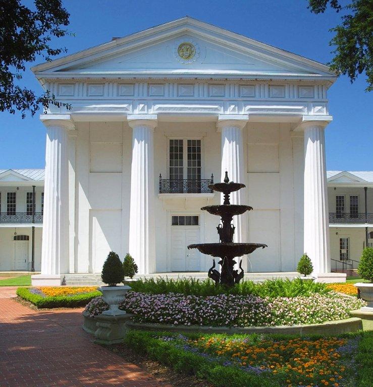
The Old State House Museum
in Little Rock. Photo courtesy
Old State House Museum.
Accessibility:  The Old State House Museum is open Monday through Saturday from 9 to 5, and Sunday from 1 to 5. The oldest standing state capitol building west of the Mississippi, the Old State House Museum has a fascinating history of its own. Permanent exhibitions tell the story of the historic building, with complementary exhibitions that explore subjects such as Arkansas political history and the legacy of Arkansas women.

The Civil War battle flags are very fragile and can only be safely displayed under controlled conditions for brief periods of time. There will be some limited display of the flags during the five exhibitions planned for the Civil War Sesquicentennial (2011-2015).

For immediate armchair accessibility, the twenty battle flags in the collection have been digitized and may be viewed online.

Background:  Flags are no longer the essential tools of war they once were. In the chaos of a Civil War battle, a flag lifted high above the fray provided visual orientation and a needed rallying point. When the flag dropped out of sight, confusion could quickly take hold.

Soldiers knew their flags and invested them with strong emotion. The flag symbolized their companions, their cause, and their regional identity. As long as the flag was held high, it symbolized hope, too.

The Old State House Museum in Little Rock preserves a remarkable collection of twenty Civil War battle flags. Each of them speaks to Arkansas’ role in the unfolding war. The collection is unique in possessing examples of all three major patterns of flags distributed to units of the Confederate Army of Tennessee.

The captured Confederate flags were retained by the United States War Department in the decades following the Civil War. The South’s vigorous participation in the Spanish-American War led to a formal gesture of reconciliation in 1905 as the federal government returned the captured battle flags to their states. In the 1950s, the State of Arkansas entrusted its Civil War battle flags to the care of the Old State House Museum.

Notes from the Editor:  Three flags from this collection were designated for special conservation treatment through Save America’s Treasures funding. As with all textiles, flags deteriorate as they age. Prolonged light exposure can distort their colors and the fabric itself can become brittle. Old attempts to create supports for the flags actually served to accelerate their deterioration. Fastened to an acidic surface, the pigments and fibers of the flags suffered further degradation. (In the before and after treatment images on this page, the acidic supports have been removed in the "after" image.)

The good news is that this flag collection can be conserved. Fundraising for the Civil War Flag Preservation Project continues at the Old State House Museum. This brief video offers a glimpse inside the museum and an introduction to the flag preservation cause:


Here’s more information on the fundraising campaign and a direct link to the online donation page where you can make a contribution toward saving Arkansas’ Civil War battle flags.

Other Recommended Sites:  A century and a half ago, the Civil War was raging. Today, the sesquicentennial is offering nearly countless opportunities to commemorate and honor our shared past. The Arkansas Civil War Sesquicentennial Commission has mounted an easy-to-navigate website that links to information on events and exhibitions planned throughout the state, as well as detailed information on Arkansas’ role in the war.


Before treatment:  Confederate First National pattern flag attributed to
"Hart's Battery."  Photo courtesy Old State House Museum.

After treatment:  Confederate First National pattern flag attributed to
"Hart's Battery."  Photo courtesy Old State House Museum.

Tour America's History Itinerary
Monday’s destination:  Little Rock Central High School
Wednesday’s destination:  Eureka Springs City Auditorium

© 2012 Lee Price